 Yes,
the proposal is large. No, it is not as large as claimed outside of
TxDOT.
Yes,
the proposal is large. No, it is not as large as claimed outside of
TxDOT.Fact Check: US 290 from Oak Hill to Dripping Springs
TL;DR: This page compares social media claims made online against the actual Option 3 that TxDOT proposed in January 2024. Most claims are proven false by the schematic drawings of what TxDOT proposed and would build.
My analysis is my own and I do not speak for the claim makers or TxDOT. For thoughts on how to actually save Dripping Springs, please see Save Dripping Springs.
As of December 2024, our input to TxDOT is summarized at Workshop Summary.
TxDOT held a Community Workshop at Dripping Springs Ranch Park, accepting public input. As no new alternatives are proposed yet, the below FAQ still applies to the last known build proposal, “Option 3” from January 2024. TxDOT is likely to provide more than 1 proposal in future public meetings.
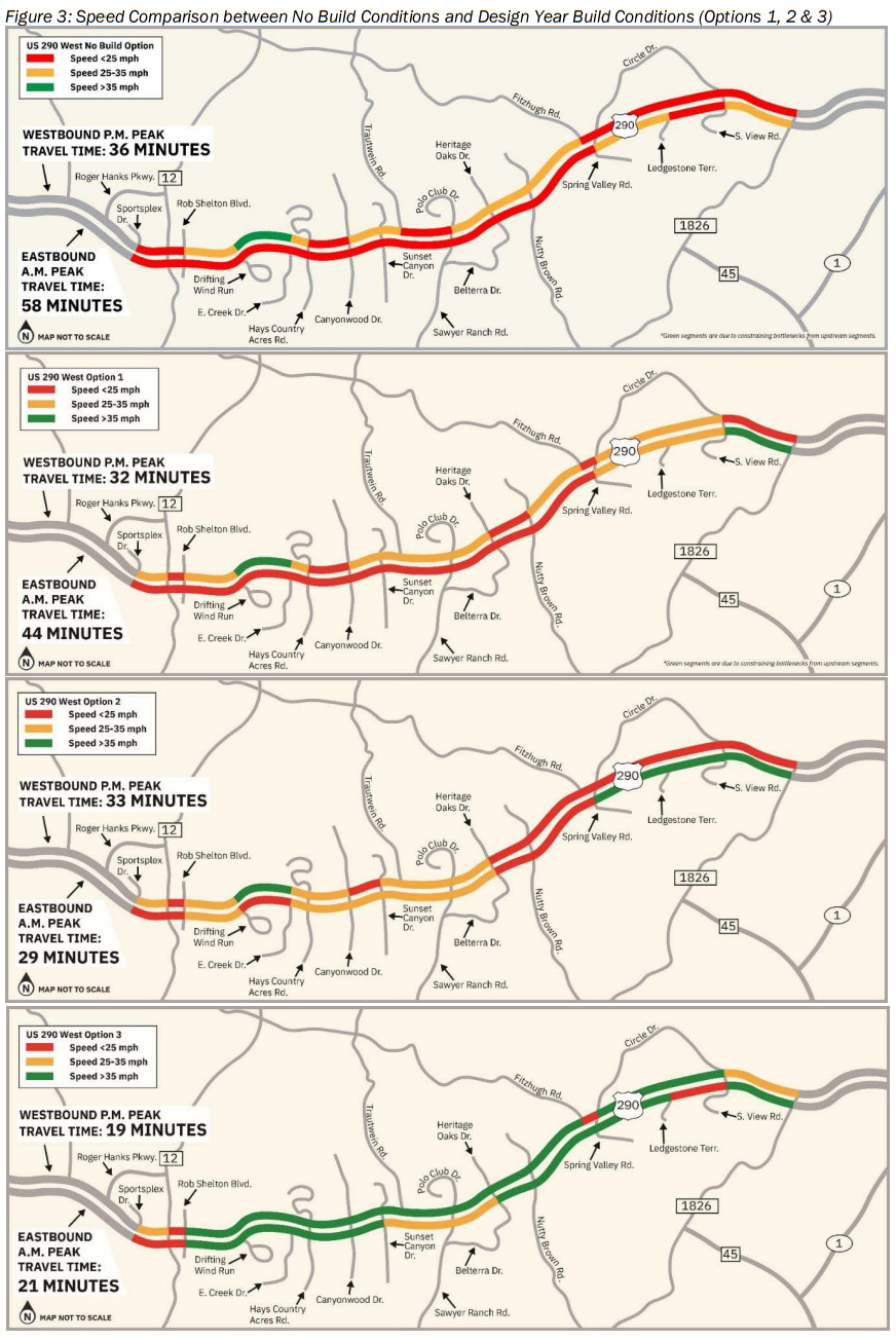
On June 1, TxDOT revealed the future speeds and travel times of options 0, 1, 2 and 3 clearly showing the magnitude needed to solve mobility for the future. Highly recommend you understand options 1, 2 and 3 of the TxDOT feasibility study (section 6) before asking TxDOT to invent an unknown option 4 that would consume 3 - 5 more years and possibly be worse than this option 3.
Yes,
the proposal is large. No, it is not as large as claimed outside of
TxDOT.
The TxDOT study since 2019 explored smaller alternatives that failed, resulting in the current option 3 proposal at 80% of standard Texas highway size. Images (click to enlarge) and figures presented here are from:
US 290 from Oak Hill to Dripping Springs TxDOT’s January 2024 public meeting, including:
Planning and Feasibility Study - see section 6 for options 1, 2, 3 (final in June 2024)
Proposed Design Schematics detailed drawings and elevations
City of Dripping Springs Traffic Study - May 2021
All claims, on the other hand, are from web sites or social media, and NOT from TxDOT.
 False.
TxDOT is literally proposing "a
six-lane divided facility with adjacent frontage roads"
as in the TxDOT images captured here, not at all like the non-TxDOT
images on other sites. Since the 4 local lanes
already exist today, the
expansion is the 6 new freeway lanes that fly over or
under the local traffic signals, replacing the dangerous center turn
lane. Ten lanes are
continuous from one end to the other, double
the current five lanes.
False.
TxDOT is literally proposing "a
six-lane divided facility with adjacent frontage roads"
as in the TxDOT images captured here, not at all like the non-TxDOT
images on other sites. Since the 4 local lanes
already exist today, the
expansion is the 6 new freeway lanes that fly over or
under the local traffic signals, replacing the dangerous center turn
lane. Ten lanes are
continuous from one end to the other, double
the current five lanes.
 “True”.
Interchange approaches have up to 6 additional short lanes. This can
include 2 AUX/merge, 2 U-turns, 1 right turn, and 1 left turn.
This is no wider than the rest of the highway as these short lanes
consume the grassy area. Note that the bridges are < 4% of the
project length so they are not a great representation of the whole
highway.
“True”.
Interchange approaches have up to 6 additional short lanes. This can
include 2 AUX/merge, 2 U-turns, 1 right turn, and 1 left turn.
This is no wider than the rest of the highway as these short lanes
consume the grassy area. Note that the bridges are < 4% of the
project length so they are not a great representation of the whole
highway.
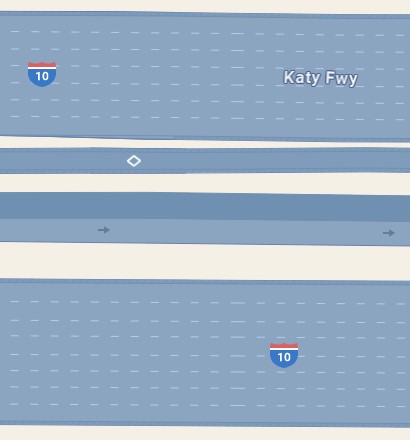
You can find 16 freeway lanes on portions of I-10 in Katy, TX. But that is no where near Dripping Springs or this TxDOT proposal.
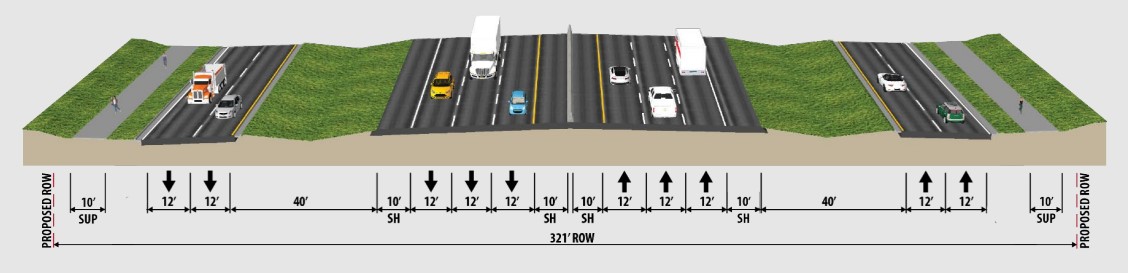
“True”. Highways are huge, especially freeways in Texas. A standard 6+4 lane divided inter-city Texas freeway like this is 400 feet wide.
False. But due to the overcrowding, TxDOT has reduced the typical footprint here to ~321 feet, the minimum practical for safe grade separated freeway and interchanges. It shrinks even smaller to 300 feet at Ledge Stone and to 250 feet near Canyon Bend. In a few places the right of way expands beyond 321 feet to accommodate water retention, utilities or other reasons.
It is fear mongering to claim this 20% smaller than average freeway is a “monster”. If this were larger than average, or vertical, then you might have a case for “monster”. But that does not exist here.
 False.
30 feet is a point in the air above the cars on the bridge!
False.
30 feet is a point in the air above the cars on the bridge!
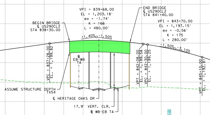
This highway is at ground level = ZERO feet except for interchanges where freeway must flow over or under the traffic signals. The bridges provide 17 to 19 foot clearances. Add the structure thickness of the bridge and the surface is less than 24 feet above the cross street below.
Clearance |
~Surface |
|
Bridge, all have 2 supports except unders (0) and Fitzhugh/Circle (11) |
16.5 |
21.5 |
|
Village Grove Pkwy aka Southern "Bypass" |
19.0 |
24.0 |
|
(under) Headwaters |
21.9 |
26.9 |
|
(under) Trautwein |
16.6 |
21.6 |
|
Sawyer Ranch Rd |
17.9 |
22.9 |
|
Belterra Dr / Heritage Oaks Dr |
16.9 |
21.9 |
|
Nutty Brown Rd(*) |
18.0 |
23.0 |
|
Fitzhugh Rd, 11 supports through to: |
19.7 |
24.7 |
|
Spring Valley Rd / Circle Dr |
18.3 |
23.3 |
|
Mean Average in Feet |
(*) On June 1, TxDOT confirmed the 26.9 clearance shown on 1 of 2 views of Nutty Brown Rd was clearly a 1 digit mistake that would never be built. Nutty brown is 16.9 foot clearance as correctly shown on the other view.
Note that the bridges are < 4% of the project length so they are not a great representation of the whole highway.
False. The average bridge clearance is 18.3 feet and surface ~ 23.3 feet, see table in previous claim. If you wish to round this to the nearest 10 feet, then “20 feet” is a fair point inside the concrete of the bridge. Your “30 feet” is a meaningless point in the air above the cars on the bridge. Of course, everywhere but the bridges (the other 96%) remains at ground level = ZERO feet.
False. From the May 2024 FAQ: “When will construction begin?”
“Construction is not funded. If a build alternative is recommended at the end of the environmental study, the project would advance next to the Final Design. If the project were to advance to the Construction Phase, it would likely be no earlier than 2032.”
Add the 2+ year delay since then and construction starts no earlier than 2035 with completion no earlier than 2040.
False. The hill country will continue to exist in place unaltered for many miles north, south and west of the highway. The highway width here makes no change to our beautiful expansive hill country that spans 25 counties.
“True”. Land owners and housing developers, on the other hand, alter their portions of the hill country. They do this independent of the width of the highway. The highway itself will be altered only within its new ~321 foot right of way.
True. This will improve traffic flow and make both local and through trips safer. The traffic LOS will be fixed east of Rob Shelton through 2050 and beyond.
This will drastically alter Cedar Valley and Ledge Stone where sadly many businesses on the north side will be displaced, see next claim.
Downtown businesses will lose parking space by the addition of only 2 lanes there. (Roger Hanks to Rob Shelton is a separate and smaller 6 lane / no-frontage road project in this proposal. Beware the future though.)
False. Housing is approved independent of the width of the highway. Dripping Springs will expand out of control whether transportation is improved or not.
True only if you meant that it will wipe certain properties or portions of them off the map. Unfortunately the expansion from 120 feet to 321 feet affects too many properties since the final right of way was not established years ago. If you delay the build, then you affect even more properties that continue to build in the needed space.
In the case of Ledge Stone or any current development, the developer building in the new right of way known since 2020 should pay for their mistake rather than innocent tax payers.
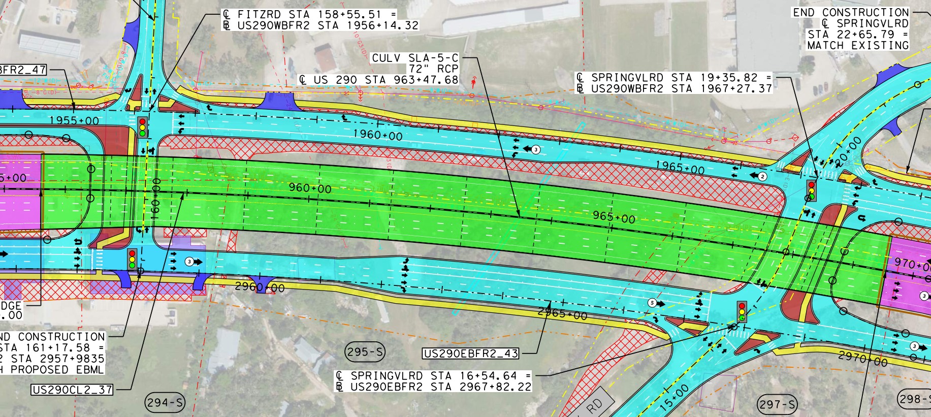
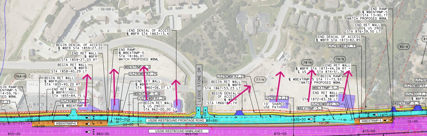
False. The 40 feet green lane separation of the first image on this page is a design fact proven by the schematic shown in the second image on this page, both verbatim from this TxDOT proposal. The green separation is a result of the 6+4=10 through lanes in the 321 feet width and is required for vehicle separation and storm water drainage.
Maybe you want the standard 400 feet wide highway instead? This would double the green gaps from 40 feet to 80 feet, or it could add 40 feet down the middle with 60 feet on the sides. While more attractive, this extra 80 feet would severely impact more properties.
“True”. The grass may be weeds or dirt due to the lack of rain. And it will not be 40 feet wide near the interchanges. There the extra AUX and turn lanes consume much of the green area to fit in the same 321 feet.
False. The schematics show that this is more like a narrow version of I-35 in Kyle with the grass separation reduced to 40 feet as shown above and below. In many places the AUX/merge lanes reduce the grass further while the overall width does not expand.
In contrast, I-35 in Austin is often wider with more lanes in several places. Austin also has lanes elevated above the ground for long distances with even more expansion under construction. These huge city features are not on this proposal.
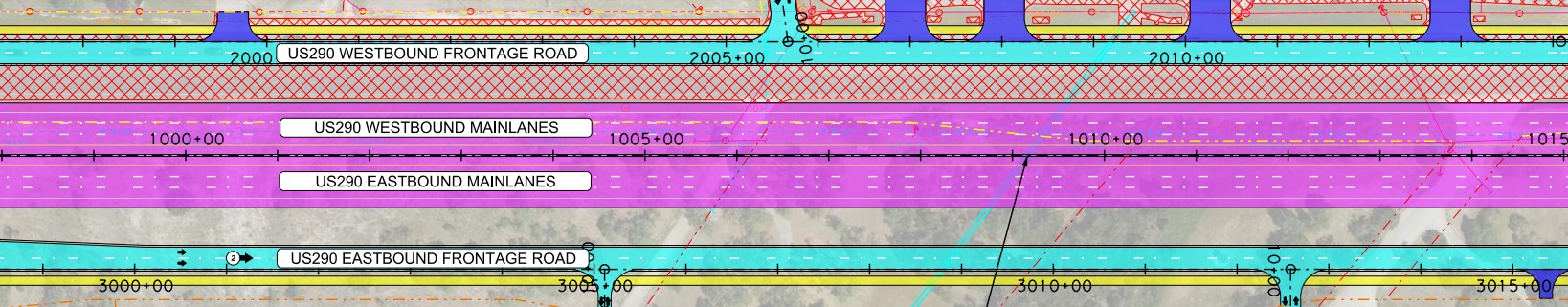
 False.
The picture on another web site shows 15 lanes elevated over more
than an intersection in Dallas. That will not exist here. This
proposal is for only the 6 through lanes and sometimes 2 AUX/merge
lanes to be elevated over the bridge only at the interchange. So this
is at most 8 lanes over the bridge. Trautwein and Highwater
interchanges send the freeway lanes under an even smaller crossing
bridge at the surface level.
False.
The picture on another web site shows 15 lanes elevated over more
than an intersection in Dallas. That will not exist here. This
proposal is for only the 6 through lanes and sometimes 2 AUX/merge
lanes to be elevated over the bridge only at the interchange. So this
is at most 8 lanes over the bridge. Trautwein and Highwater
interchanges send the freeway lanes under an even smaller crossing
bridge at the surface level.
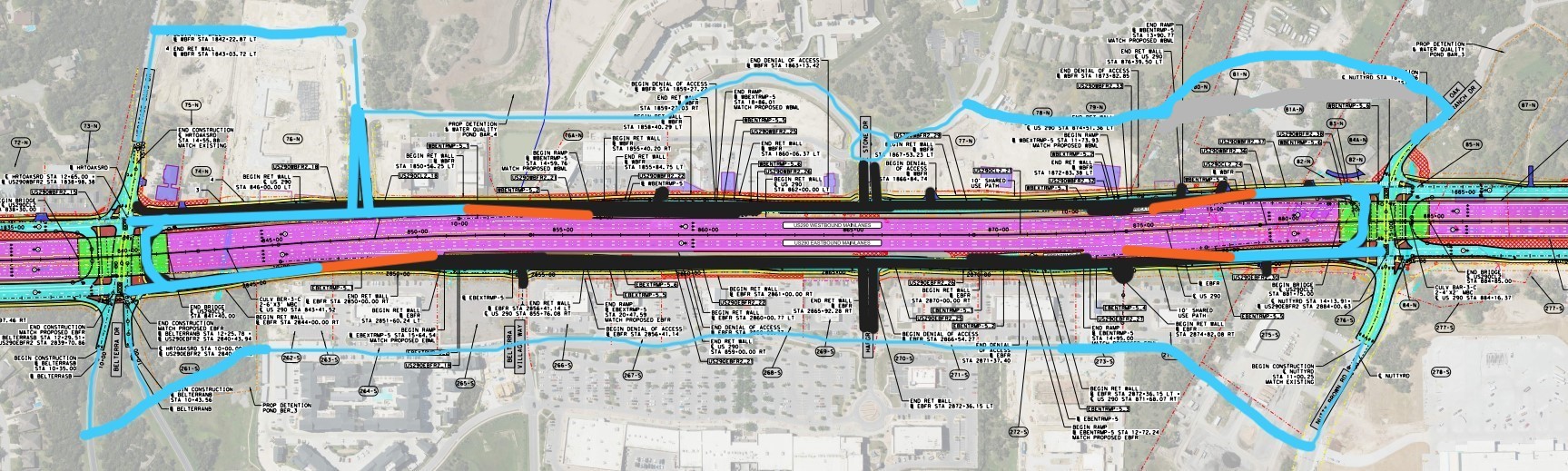
Additionally, all bridges are short with 2 supports except for Fitzhugh to Circle Drive. These are so close together that the bridge must remain elevated over 11 supports. But on this longest stretch only 6 lanes are elevated as shown here.
False. This is physically impossible as such a place does not even exist! I-35 never crosses Manchaca.
“True”. But Ben White and Manchaca does exist and a web site shows this. The image includes an elevated on ramp that does not exist in this proposal. If that extra lane were not there, then it would be a closer approximation. Also, Ben White remains elevated for a long distance west of Manchaca while extended elevation exists in this proposal only over 11 supports as shown here in previous claim.
False. This is TxDOT’s “no build” baseline, let’s label it “Option 0”. They will gladly go spend your gas tax money elsewhere if not here.
But Grade
E LOS already exists in some places with >
33,000 trips per day (2018) and
20
22 people
have lost their lives in
crashes since 2014. 4.8% of crashes are severe compared
to 2.8% state average. How many lives should be lost before safety
improvements are made?
This is forecast to grow to > 84,000 trips per day by 2040. If decision, final plan, property acquisition, utility relocation and funding take 5 years then construction likely starts after 2035 with completion after 2040. How is this is not needed a decade from now with 250% of today’s traffic? Or 30 years after that? Putting > 50,000 trips per day around a middle turn lane could be considered negligent.
False. This just makes traffic LOS worse. It is the signals and overloaded lane count that already cause delays. TxDOT will not target Grade F results that make no improvements in safety and efficiency.
False. This is the “Option 1” in section 6.1 of the Feasibility Study:
“Option 1: Adding one additional lane in each direction for a total of three lanes in each direction, with the existing signalized intersections remaining in place. The traffic analysis results determined that this option would continue to operate at a poor LOS E/F along most US 290 study corridor roadway segments and intersections. Consequently, Option 1 was dismissed from further consideration resulting in the development and evaluation of Option 2.” -TxDOT
False. This is the “Option 2” in section 6.1 of the Feasibility Study:
“Option 2: The same as Option 1 plus adding overpasses and ramps at major intersections. The traffic analysis results determined that this option would slightly relieve congestion at the major intersections but would continue to operate at a poor LOS E/F along most US 290 study corridor roadway segments from Trautwein Road to the US 290 western intersection with Circle Drive. Consequently, Option 2 was also dismissed from further consideration resulting in the development and evaluation of Option 3.” -TxDOT
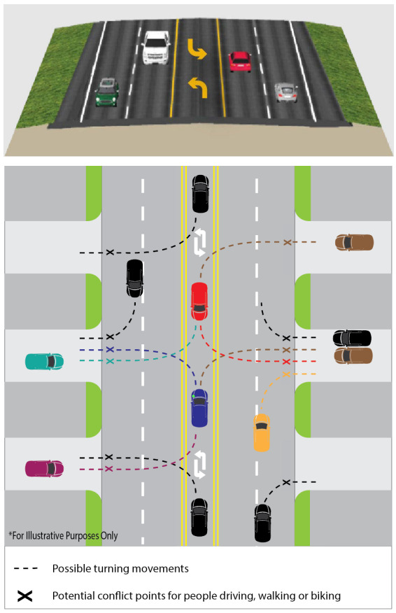
The reason conventional intersections don’t work in Texas is that the requisite nearby parallel streets do not exist. In places without frontage roads, interchanges take you to nearby parallel streets that provide business access. But those streets do not exist in this area where all businesses are built right on the highway. No one planned and built the parallel street spanning all properties in advance, so you are stuck with mandatory frontage road for local access.
True. This is the only way to get to local businesses and residences while having a grade separated freeway for through traffic. Where would you build parallel streets instead? See previous claim.
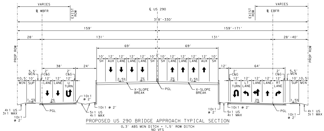
False. A "Michigan left turn" is similar to US 290 East to Scenic Brook North before the new bridge opened (June to October 2024). In other words, you go past the intersection to a U-turn then across ALL opposite fast lanes to a right turn to your exit. To enter highway (Scenic Brook South to US 290 East) you turn right, cross ALL fast traffic lanes and make a U-turn to merge with high speed traffic.
Please ask the people of Scenic Brook if they like the previous Michigan left better than their new overpass. While this was used here in construction it was intended to be temporary. We have heard online that some residents were already afraid to cross the current 2 busy highway lanes. How will they cross 3 instead? And for most streets, the traffic signal must go red to enable cross traffic which backs up all highway lanes at rush hour. Then crossing 3 lanes becomes impossible, backing up the U-turns. Then the traffic doubles or triples by 2054 design year!
Hall Road near Detroit handles 80,000 trips per day as needed here. But this is 350 feet wide, 29 feet wider than Option 3!
“True”. If you wish to upgrade this wide build to Option 3 freeway later. Michigan left requires very wide median making it wider than divided freeway! But this is a waste of tax payer money to build the highway twice instead of once.
The U-turn radius must be the same minimum as TxDOT proposed to safely turn semi-trailer trucks. For smaller roads the oncoming lanes can be inside the U and the road can go even narrower using the “bulb out” or “loon” trick. Both are more dangerous as you cross perpendicular to fast oncoming traffic. For higher volume like here you must move the oncoming lanes outside the U-turn, give a merge lane for crossing and add a dedicated right turn exit lane (like summer 2024 Scenic Brook example) then you are safer moving in the same direction as fast traffic. But now you are 29 feet wider than Option 3, see Hall Road near Detroit.
Either way, the safety of this is highly questionable with semi-trailers, cars and motorcycles much slower than 3 to 4 lanes of fast highway traffic while making the U-turn. The people of Texas prefer 10 lanes in 321 feet (Option 3) over 8 lanes in 350 feet (Hall Road near Detroit, MI).
False. TxDOT is already at the drawing board during this environmental study phase. That petition already worked and is no longer needed. As of the June 1 update, the clock is reset and the public feedback time extended and being reviewed. In future meetings, TxDOT will likely present > 1 build option based on your input along with no build.
Note that the petition was based on false or misleading fear mongering claims, see them above and below.
Note that the petition offered no alternative, so what did its signers sign up for? Did it mean you reject the original Option 3 from January? With option 0, 1, 2 and now 3 ruled out, you are requesting an unknown option 4? When it is revealed in 3-5 years, what will it be? You might hope it would be a divided 6 lane highway with protected U turns at the signals. But if this is LOS E/F in 2050, it is also automatically rejected. So then what is it? 26 miles of backage roads 1000 feet away? Fitzhugh a freeway to 281? These are impractical, far more destructive and costly than Option 3.
We the people cannot afford to repeat the 30+ year traffic jam of Oak Hill. It is crucial that this is approved and proceeds as quickly as practical to have any hope of handling the coming 84,000+ trips per day to save our town.
False. Improving emergency response time is a goal of this proposal. The worsening LOS slows down emergency services too, mostly by being stuck in congestion at the traffic signals or blocked by the accident with no alternate paths.
Like all traffic, emergency vehicles will flow continuously over the traffic lights and get to you sooner. Taking the U-turn to get to you on the other side is often no longer than waiting for the oncoming traffic to clear as you do today.
False. Frontage road properties in particular are more valuable to commercial developers. Most residential properties are further away from the highway and studies say values go up when mobility improves. Being “closer” to Austin makes you more valuable. In central Texas, the width of the highway has little to do with property values that continue to follow the overall area trends. This is proven by other Austin suburbs that got highway expansion and continued to go up (and down) in values with Austin.
Did Oak Hill property values plummet in 2021 when construction started? They did not. Did values plummet in 2024 with construction well under way? They did not, they decreased the same as the whole Austin area. Will Oak Hill values plummet in 2027 when the Oakhill Parkway is complete and working? Again they will simply follow area trends.
“True”. But many of us are here to live, not to sell. So if we happen to get lower value and pay less taxes, that would be a wonderful benefit. Actually, values already dropped but that has nothing to do with this highway proposal. Values dropped all around Austin, independent of highway size.
False. Cars and trucks cause the pollution, not highways, and modern vehicles less so. Parking all exhaust pipes at high density at all traffic signals is more pollution than letting them continue through quickly on a freeway in 1/3 of the time.
False. The highway is already there with cars already making the noise, so this is no change. I live within 1/2 mile and don’t hear the highway except for sirens.
False. TxDOT is aware of the Dark Sky status of Dripping Springs. They are planning color of 3000K or lower directed down only where required such as on ramps and intersections. The intent is to project no light upward and preserve our dark skies.
False. All development, including roads, requires the same or less storm water runoff after construction than before. Notice the water retention ponds and earth filters being installed on Oak Hill Parkway. The same would happen here. It is part of the reason the design phase is expensive. It is possible the new highway would filter water better than the current one built before such regulations.
False. Sorry, but you did that wrong. To fully escape city growth and traffic, you will need to be at least 5 miles from all city limits and highways. 10 miles or more is even better to escape city growth for more years. If you need rural Hill Country, then you have over 20 other counties to choose from, most further from cities.
True. But many of us are thankful to live right here in this beautiful Gateway to the Hill Country. While close to the city and its traffic, we still enjoy plenty of hills and trees not touched by the highway plan.
True. Of course, this affects us all. Those losing some or all property are affected the most, see above claim.
The rest of us are affected by the safety and efficiency of the highway we must travel every day or week. None of us have any power to slow down the land sales or traffic. “Don’t build it and they won’t come” has never worked here. And the laws let everything build before the transportation. Our only hope is to try to get road improvements ahead of developers, as impossible as this is.
Oh. I studied the data and public documents as best I could. Others have an opposite view. This is normal. Everyone is free to believe TxDOT would build what it drew, or build what someone said online. I believe they would make a final plan and then build that (with some design/build flexibility), just like they are doing in Oak Hill Parkway. We saw TxDOT listening at the June 1 workshop. The above still stands per the Option 3 from January 2024 as it is the last known proposal.
Let me know what I missed and I will try to look up an answer.
Tim Witham <twitham@sbcglobal.net>